Saturday, March 9, 2013

Environmental Geography: Mountains and Water Systems

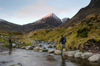
Hikers trek through an Irish mountainside.


Ireland is home to two of the great mountain systems in Europe:  the Caledonian and the Armorican. The Caledonian system runs through the north-western portion of the country, with its highest mountains made of quartzite, which creates narrow, cone-shaped peaks. The Armorican range is younger, and extends through the southern portion of Ireland. One of its mountains, Carrantouhill in the Magillycuddy Reeks, holds the record for being the highest peak in the country, topping off at 1041 meters (about 3415 feet).

These two major mountain systems surround the heart of Ireland, a limestone-floored lowland that opens to the Irish Sea on the east and the Atlantic Ocean on the west through numerous bays. This lowland, however, is not completely flat. It is broken up by hills, which continue to rise toward the west until their abrupt termination at the Cliffs of Moher, which are known as some of the most beautiful cliffs in Western Europe. The header image of this blog is, in fact, a picture of these cliffs.

River Shannon


As for water in the country, River Shannon wins the title for the largest river in the country, running 340 kilometers (roughly 211 miles)  in length. This river is home to the country's earliest hydro-electric power scheme, and at its center River Shannon broadens into multiple beautiful and popular lakes.

The second largest river in the country is the Barrow River. This river runs roughly 69 kilometers (42 miles), which still pales in comparison to the country's largest river. It streams through major towns like Carlow Town and Bagenalstown, and is known primarily as a coarse angling river.

The River Slaney is often considered the best river for salmon fishing in  the country. It extends south from Lugnaquillia Mountain in County Wicklow to the Wexford Harbor, which served as a key shipping center during the 19th century. This river only spans about 117 kilometers (73 miles), a fraction compared to the massive River Shannon.

Sources:

Green, M.  (2013).  An Outline Geography of Ireland.  Retrieved from http://www.ireland-information.com/reference/geog.html#PHY

Lodged, L.  (2010).  River Shannon from Drumsna Bridge.  Retrieved from http://commons.wikimedia.org/wiki/File:River_Shannon_from_Drumsna_bridge.jpg

River Slaney.  (n.d.).  In Encyclopædia Britannica online.  Retrieved from http://www.britannica.com/EBchecked/topic/548054/River-Slaney

Visitravel, Ltd.  (2010).  Rivers in Ireland.  Retrieved from http://blog.goireland.com/2010/01/19/rivers-in-ireland/#axzz2N3yOcGef

Wang, C.  (2013).  Hiking in Ireland.  Retrieved from http://www.prattlibrary.org/booksmedia/blog/prattchat.aspx?id=78343&blogid=12298#.UTmIGTC1eAg

Environmental Geography: Concerns


The greenery of Ireland that allures visitors is in peril.

Though Ireland has a forgiving environment, the country faces numerous environmental concerns. According to the EPA, who releases a report every year that discusses the state of Ireland's environment, the air and water pollution, littering, and poor waste management have become major concerns. A recent survey stated that 35% of groundwater samples showed fecal contamination from nearby farms. On a more positive note, 85% of lakes and 70% of lakes and rivers (respectively) were in good condition. Nevertheless, water quality and pollution are two environmental concerns that the Irish government has been taking steps to reduce such issues through taxation, recycling programs, and sustainable farming programs.

In a 2012 survey compiled by Germanwatch and Climate Action Network Europe, Ireland was ranked 9th in how well they are combating global warming. This puts the country eight spots ahead of their previous 17th ranking in 2011. The economic decline is a factor contributing to Ireland's higher score, because the deflation of the economy and job loss has significantly cut the country's CO2 emissions. The organizations in charge of this survey advise against any restarting of the economy because this will only lead to more emissions, unless further steps are put into place to create government policies that encourage energy efficiency.

Though they have leaped up on this survey, Ireland is still experiencing some of the results of poor environmental maintenance. The country's average temperature has been increasing at a rate of 0.8 degrees Farenheit per decade since the 1980's, which is faster than the averages of the other countries in the world. In the future, this will most likely cause a much drier climate in the inlands and put the country's largest crop, the potato, in danger. The fish population may become endangered, and the signature greenery of Ireland will begin to brown.

The climate change in the country may lead to an uneven distribution of water and rainfall in the country, slashing the residents' current access to water. At the same time, the coast continues to gobble up about 750 acres of the island each year, increasing the risk of widespread and long-lasting flooding. These effects will continue to culminate, especially if Ireland's economy begins to grow after its last downturn. In response to these issues, the Irish government has pledged to reduce its emissions by 20 percent. Only time will tell if these promises are kept and if the government can, in fact, save the country. 

Sources:

McCormack, G.  (n.d.).  SLG 139.  Retrieved from http://www.garethmccormack.com/stock/image/visitors-admiring-glencar-waterfall-co-sligo-irela/

McDonald, F.  (2012, December 4).  State improves performance on global warming.  The Irish Times.  Retrieved from http://www.irishtimes.com/news/state-improves-performance-on-global-warming-1.786

Scott, S.  (2009).  Environmental Concerns.  Retrieved from http://www.movetoireland.com/movepag/miscenvr.htm

The Select Committee on Energy Independence and Global Warming.  (n.d.).  Keeping the Emerald Isle Green.  Retrieved from http://globalwarming.markey.house.gov/impactzones/ireland.html

Environmental Geography: Landform and Climate

Physical Map of Ireland.

Ireland is an island located to the west of Great Britain. It is the third largest island in Europe, making it the twentieth largest island in the entire world. In 1921, the country was split into two parts:  Northern Ireland, which is a part of the United Kingdom, and the independent Ireland, which contains 26 counties.

The Irish Sea separates Ireland from Great Britain on the east coast. On the west coast, the country terminates at the Atlantic Ocean.

As a result of two major glaciations, the island of Ireland contains many mountain lakes, ice-smoothed rocks, and deposits of glacial rocks and sand.

The country boasts a temperate climate, giving its residents cool winters and mild summers, a result of the warm ocean waters Ireland receives from the North Atlantic Drift.  Th coldest months of the year are January and February, with average temperatures between 4 and 7 degrees Celsius (39 to 44 degrees Farenheit). On the other end of the spectrum, July and August boast the warmest months, with average temperatures of 14 to 16 degrees Celsius (57 to 60 degrees Farenheit).

Rain is quite common all year-round, especially on the westward facing slopes. This feature is the direct cause of the country's intense greenery. The country also lacks many trees, which is the result of the strong winds that inhibit growth.

Ireland also includes numerous islands surrounding its coasts. The largest of these islands is Achill, which is considered by tourists to be an unspoiled paradise. It is known as a place of peace and solitude, with beautiful beaches and many popular water sports. The video demonstrates the utter beauty of this island.


Sources:

Green, M.  (2013).  An Outline Geography of Ireland.  Retrieved from http://www.ireland-information.com/reference/geog.html#PHY

Green, M. (2013).  Land and People - Physical Features and Climate.  Retrieved from http://www.ireland-information.com/reference/physical.html

Mayo Ireland.  (2010).  Achill Island.  Retrieved from http://www.achill.com/

Mccan, P.  [tittlethepipes].  (2009, April 7).  Sunlit Streams [video file].  Retrieved from http://www.youtube.com/watch?feature=player_embedded&v=itEKGFzWigA#!

Vidiani.com.  n.d..  General Map of Ireland.  Retrieved from http://www.vidiani.com/?p=2339